
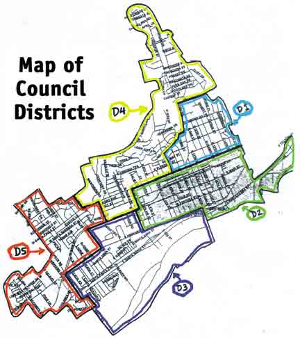
In addition, McDermott noted that the council must determine the ballot language for the proposition, largely specified by statute, which will be put before voters in the November election.Districting is proposed to create more Latino representation on the City Council, the basis of the DOJ lawsuit.Approximate district borders would be: District 1 at Say Road to eastern city limits and Santa Paula Street to the south, ranging along Ojai Road to High Street and McKevett Road and Mill Street; District 2 would be all areas below District 1 to Harvard Boulevard, bordered on the west by Olive Street and South Palm Avenue; District 3 would be an area bordered by Peck Road and 10th Street, ranging up Steckel Drive and North Palm; District 4 would be the northern portion of the city, north of Say and Ojai roads, include a portion of Santa Paula Street and end at Atmore Drive; District 5 would be west Santa Paula, from Harvard Boulevard, up to Skyline Drive and west to city limits.District 1, according to Census 2000 data on surnames, has a Latino population of 85.76 percent; District 2, 85.58 percent Latino; District 3 has a Latino population of 72.55 percent; 50.12 percent of District 4 is Latino; and District 5 is 61.02 percent Latino.
|
Council approves voting districts, public hearing will finalize plan
March 29, 2002
Santa Paula City Council
The City Council, with little discussion, approved the five-member district plan prepared by the U.S. Department of Justice, which will have to undergo a public hearing before being finalized.
The council approved the plan at the March 18, just the latest step in the resolution of the voting rights lawsuit filed against the city in 1998 and settled last year
By Peggy KellySanta Paula TimesThe City Council, with little discussion, approved the five-member district plan prepared by the U.S. Department of Justice, which will have to undergo a public hearing before being finalized.The council approved the plan at the March 18, just the latest step in the resolution of the voting rights lawsuit filed against the city in 1998 and settled last year.City Attorney Phil Romney said that during the course of litigation, the DOJ proposed a five-district planning crafted with 2000 census data. The council could order an alternative five-district map be done by a consultant at an estimated cost of up to $5,000, which could be drawn from the city’s Department of Justice lawsuit account, which has a current balance of $88,000.Attorney John McDermott, who represented the city in the DOJ lawsuit, wrote that the proposed DOJ district plan meets all legal criteria, including all demographic data utilized by cities and counties in redistricting.
