
Artists have been painting the St. Francis Dam flood map on the walls of the museum exhibit area, along with images of the disaster including a silhouette of William Mulholland, who designed the ill-fated dam, and Red Cross nurses giving aid to survivors. Among other items on exhibit, Nichols said there are “hundreds and hundreds of photographs, many never before seen.”Wanting a “new angle” for this exhibit, Nichols shows that the St. Francis was part of a system of many dams, “not a single entity. It had systemic problems that led to its failure, but just imagine if the St. Francis had never needed to be built. Our history changed from it: our opinion of Mulholland, Owens Valley” drying up to a desert, “the creation of Santa Paula Airport, it’s a fictional device of ‘What if this hadn’t happened?’ “Orcutt said that also of special interest are the series of four-foot long panoramic photographs taken by Ventura photographer Bernie Isensee to document the devastation, commissioned by the Ventura County District Attorney, who foresaw the possibility of a lawsuit against Los Angeles County. “A week after they were taken the two counties settled damage and death claims out of court,” said Orcutt. “We are grateful today that these photographs were taken and survive.”“Sometimes positive things occur as the result of a disaster,” Nichols noted, such as the dam safety laws implemented almost immediately after the collapse. “We learned that the citizens of Santa Paula could rise to the occasion by being everyday heroes.”The museum is open Wednesdays through Sundays from 10 a.m. to 4 p.m. Admission is $4 for adults, $3 for seniors and $1 for children (ages 6-17); children under 5 are free, as is admission for museum members. The exhibit continues through July 27th. For more information call the museum at 933-0076, or visit the website www.oilmuseum.net.
|
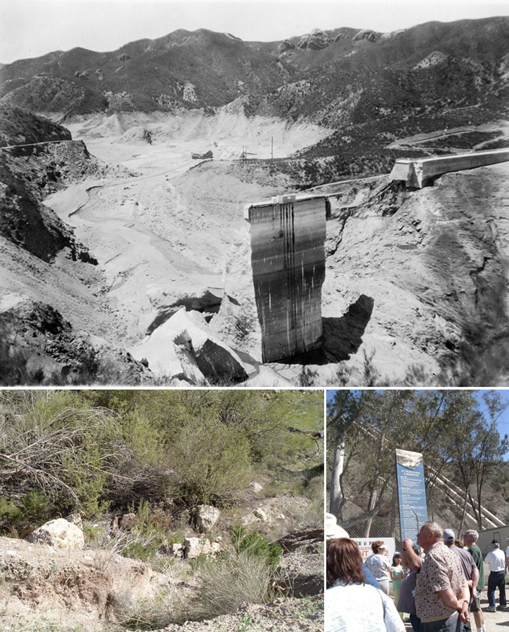
(Top photo) This is what is left standing following the St. Francis Dam collapse March 12, 1928. Floodwaters rushed down the Santa Clara River, devastating communities along the way and taking many lives. (Photo Courtesy of JohnNicholsGalley.com) (Bottom left) “All that remains downstream from the St. Francis Dam are chunks of the low-grade concrete that litter the landscape… only a few larger pieces show the “steps” that marked the dam’s design. (Bottom right) “The marker at Power House 2, broken into bits by the 1928 collapse of the St. Francis Dam, stands near the replacement building built one year later on the original foundation.” (Bottom photos by Peggy Kelly) |
St. Francis Dam Disaster, March 12, 1928
March 12, 2008
St. Francis Dam: 80th anniversary of disaster focus of new Museum exhibit
Santa Paula News
By Peggy Kelly
Santa Paula TimesAlthough most Santa Paulans are familiar with the story of the St. Francis Dam disaster, there’s an often-overlooked back story of the events that led to the building - and collapse - of the St. Francis.That back story, as well as tales of survivors, never-before-seen photographs and unique maps will be the focus of Sunday’s opening reception of the Santa Paula California Oil Museum “St. Francis Dam Disaster: 80th Anniversary” exhibit, curated by John Nichols - author of “Images of America: St. Francis Dam Disaster” released by Arcadia Publishing - and Jennifer Heighton. The March 16 reception will be held from 1 to 3 p.m. at the museum, located at the corner of 10th and Main Streets.The St. Francis failed just minutes before midnight on March 12, 1928, its 200-foot-high concrete wall crumbling, sending billions of gallons of raging flood waters down San Francisquito Canyon, about five miles northeast of what is now the city of Santa Clarita. The avalanche of water swept 54 miles down the Santa Clara River Valley, sweeping away all in its path as the flood made its way to the ocean. The exact death toll will probably never be known, but more than 450 people in Los Angeles and Ventura counties perished in the disaster.“This major exhibit will examine the full history of the disaster, from the building of the Los Angeles Aqueduct to the building of the dam and its unbelievable collapse and the horrific aftermath,” said SPCOM General Manager Jeanne Orcutt. “Many inspiring stories of heroism in the face of disaster are also told in the exhibit.”Nichols said that interest in the disaster has built over the years: “There’s no letup... the 80th anniversary comes along and you think interest will taper off, fewer survivors are left. Maybe it’s the increasing exposure that built awareness in the public’s consciousness about this exciting story. Even if people saw the 75th anniversary exhibit, they want to come back to see more and learn more” about what is considered the greatest engineering failure of the 20th century.“Without the Los Angeles Aqueduct the St. Francis Dam never would have been filled, and it’s part of the story” that Nichols has included in the exhibit, which includes the “world’s longest map, it’s in four pieces and over 70 feet long that traces the elevation” of the area between the Owens Valley and Los Angeles’ Antelope Valley where the gravity fed 233-mile Aqueduct was constructed. “The map shows the elevation of every foot, every mile of the complete course of the aqueduct,” said Nichols, who obtained the 1917 map from the collection of a Los Angeles Department of Water & Power engineer’s private papers.

